Having completed and mounted the interpretive labels for the exhibit, I realized that the exhibit needed something to demarcate its entry point. I wanted to include maps of the region and to include historical context for visitors. I located historical maps and developed additional interpretive labels to accompany the maps. With these elements, I designed a large poster for the exhibit entry.
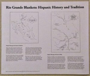 The first map shows the Rio Grande Valley including Colorado, New Mexico, and Mexico, and shows early trade routes. The accompanying text: Hispanic Weaving in the American Southwest describes the rise and trading of Rio Grande blankets. The second map shows the San Luis Valley, Colorado and the two land grants that lead to settlement in this valley, bounded and separated by the Rio Grande: the Conejos Grant on the east and the Sangre de Cristo Grant on the west. The accompanying text: Hispanic Weaving in the San Luis Valley, Colorado discusses settlement of the valley, the rise of sheep ranching among Hispanic settlers, and the arrival of railroads with commercial goods that contributed to the decline in traditional Hispanic weaving. With the installation of this poster at the entry point, the exhibit was complete.
Maps from: Sarah Nestor, editor. Spanish Textile Tradition of New Mexico and Colorado. Museum of New Mexico Press, 1979.